AZSITE is a geographic information system (GIS) that serves as a consolidated informational network of recorded cultural resources; including prehistoric and historic sites and properties, and surface surveys. AZSITE includes data from many sources including the Archaeological Records Office (ARO) and the State Historic Preservation Office (SHPO). The data included within AZSITE fall within the State of Arizona and a 40-mile buffer around the state.
The data are accessible through a series of public and secured internet applications and tools.
To gain access to AZSITE’s secured information submit the 2025 online application.
All users are vetted by the SHPO personnel and may be required to supply a current CV before access is granted.
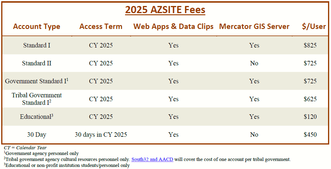
Fees for the secured portion of AZSITE are based on user organization, data access options and duration of access. There are no state budgetary funds to develop or maintain AZSITE. This online resource relies on user fees.
Yes. Two components of AZSITE are open to the public. Both are available free of charge.
AZSITE Public provides the percentage of each PLSS section's area that has been surveyed within the past ten years, and the percentage of each PLSS section's area that is covered by sites. These data are based only on AZSITE's database. The application also provides land ownership and related context.
FAUNAZ provides specific information on faunal remains found around the state at cultural resource sites. This application was originally funded by a grant from Arizona Game and Fish. The application is old and some pieces of it no longer work, but the functional parts may be of use. We are investigating options to overhaul this application.
There are three ways for users to access AZSITE data.
AZSITE Member Mapping allows access through a web browser. Web Access requires only a standard desktop web browser and supports Chrome, Explorer, Firefox, and Safari.
Users with a Standard I account have access to the Mercator server which allows you to view and manipulate AZSITE data using ArcGIS, QGIS, ArcGIS Pro, and other GIS software.
Data can also be requested from the AZSITE Manager. Please see “Q: Can AZSITE users request data from the AZSITE Manager?” for instructions on making this request.
No. The Arizona State Museum (ASM) is the official and only repository for records generated under Arizona Antiquities Act (AAA) Blanket Permits (i.e., non-collection survey projects on state lands). The ASM’s Archaeological Records Office (ARO) receives, reviews, processes, and curates project materials submitted in compliance with AAA-permitted work.
We recommend that all consultants either visit the ARO or formally request a record search from the ARO to ensure all available data is gathered, including recent surveys and newly recorded sites.
Data downloaded from the AZSITE website may not otherwise be complete.
No, please see “Q: Is AZSITE the repository for survey records conducted under an Arizona Antiquities Act Blanket Permit for the state of Arizona?”.
Additionally, data from projects and sites located on Tribal land are not included in the AZSITE data set. For more information, please contact the Tribal Historic Preservation Office (THPO) for each Tribe the project area intersects.
Please see “Q: Is AZSITE the repository for survey records conducted under an Arizona Antiquities Act Blanket Permit for the state of Arizona?”.
For more information, visit the Arizona State Museum (ASM) website’s Frequently Asked Questions section.
Yes, shapefiles of the data currently available on AZSITE can be clipped for fee-paying AZSITE users on a per project basis.
Please complete the web form to request AZSITE data.
The company you are moving to can add you to their license using the online application.
The company you are leaving should also send an e-mail to the AZSITE Manager (gmcgowan@arizona.edu) to let them know to remove you from their account.
If your project is being registered/curated with ASM, follow the submission instructions provided by the ARO. There are fees associated. ARO staff will pass the data directly to AZSITE following curation.
AZSITE displays data from multiple agencies but does not curate these data. Courtesy submissions to AZSITE do not replace curation requirements but, rather, are typically submitted when there are no requirements to curate at ASM. All projects registered/curated with ASM are forwarded to AZSITE; there is no need to submit data to both institutions.
If you wish to submit data to AZSITE for work done on Private or Federal lands that do not require that ASM be the curation facility, then you may submit shapefiles and entry module to be displayed in AZSITE free of charge. AZSITE courtesy data can be submitted directly to AZSITE digitally or by mail. These courtesy submission data cannot use ASM Accession or Site Numbers.
If you wish to update a previously recorded ASM Site on Private or Federal land, either (1) use a different site numbering system if the project will not be registered with ASM, or (2) register the project with ASM for an official change to the previously recorded ASM Site boundary. See the ASM project submission guidelines for further information.
If submitting digitally, please contact the AZSITE Manager for submission instructions. If submitting by mail, send a CD or USB drive containing the completed entry module and shapefiles for project and all sites and/or site updates to: